2 Waltz courses
Get a 10% discount on your first order when you use this promo code at checkout: MAY24BAN3X

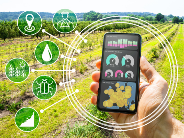
Step into the fascinating world of 'Geospatial Technology, Remote Sensing, and Web Mapping,' where learning becomes an exciting voyage. This course is not your typical academic roadmap; it's a dynamic adventure that plunges you into the intricate dance between technology and geography. From untangling the threads of Geographic Information Systems (GIS) Basics to harnessing the capabilities of Remote Sensing, each module unfolds as a thrilling chapter in your expedition toward spatial expertise. Envision not just absorbing knowledge but actively shaping the landscape of the future. This course isn't a lecture; it's an invitation to embark on a daring escapade, challenging you to lead the charge in spatial exploration. Join us and redefine the boundaries where data and vision collide. In this educational escapade, modules don't unfold; they reveal themselves like captivating tales, guiding you through the technological evolution. Traverse the landscapes of spatial data management, waltz through the artistry of web-based mapping, and immerse yourself in the wizardry of geospatial programming. This isn't just about accumulating information; it's about emerging as a pioneer, armed with skills that defy convention. Enlist now to navigate a future where every data point holds the promise of revelation, and every map transforms into a canvas of possibilities. Learning Outcomes * Develop an in-depth understanding of Geospatial Technology, bridging the gap between theory and hands-on applications in real-world projects. * Master the essentials of Geographic Information Systems (GIS), skillfully utilizing spatial data for insightful analysis and decision-making. * Cultivate expertise in spatial data management, ensuring the efficient organization of geospatial information. * Explore advanced spatial analysis techniques, extracting meaningful insights from intricate geographic datasets. * Unleash the potential of Remote Sensing and Imagery, gaining heightened awareness of Earth's surface and environmental dynamics. WHY CHOOSE THIS GEOSPATIAL TECHNOLOGY, REMOTE SENSING AND WEB MAPPING COURSE? 1. Unlimited access to the course for a lifetime. 2. Opportunity to earn a certificate accredited by the CPD Quality Standards and CIQ after completing this course. 3. Structured lesson planning in line with industry standards. 4. Immerse yourself in innovative and captivating course materials and activities. 5. Assessments designed to evaluate advanced cognitive abilities and skill proficiency. 6. Flexibility to complete the Course at your own pace, on your own schedule. 7. Receive full tutor support throughout the week, from Monday to Friday, to enhance your learning experience. 8. Unlock career resources for CV improvement, interview readiness, and job success. WHO IS THIS GEOSPATIAL TECHNOLOGY, REMOTE SENSING AND WEB MAPPING COURSE FOR? * Tech enthusiasts eager to unravel the fusion of geography and cutting-edge technologies. * Visionaries in environmental science, urban planning, or data analytics. * GIS professionals hungry for skill enhancement and the latest industry insights. * Aspiring geospatial programmers, ready to script the future. * Urban planners and policymakers keen on integrating geospatial tools for strategic decision-making. CAREER PATH * Geospatial Visionary: £25,000 - £35,000 per annum * GIS Alchemist: £30,000 - £40,000 per annum * Remote Sensing Maestro: £35,000 - £45,000 per annum * Web Mapping Virtuoso: £28,000 - £38,000 per annum * Geospatial Code Wizard: £26,000 - £36,000 per annum * GIS Applications Guru: £30,000 - £40,000 per annum PREREQUISITES This Geospatial Technology, Remote Sensing and Web Mapping does not require you to have any prior qualifications or experience. You can just enrol and start learning.This Geospatial Technology, Remote Sensing and Web Mapping was made by professionals and it is compatible with all PC's, Mac's, tablets and smartphones. You will be able to access the course from anywhere at any time as long as you have a good enough internet connection. CERTIFICATION After studying the course materials, there will be a written assignment test which you can take at the end of the course. After successfully passing the test you will be able to claim the pdf certificate for £4.99 Original Hard Copy certificates need to be ordered at an additional cost of £8. COURSE CURRICULUM Module 01: Introduction to Geospatial Technology Introduction to Geospatial Technology 00:18:00 Module 02: Geographic Information Systems (GIS) Basics Geographic Information Systems (GIS) Basics 00:22:00 Module 03: Spatial Data Management Spatial Data Management 00:20:00 Module 04: Spatial Analysis Techniques Spatial Analysis Techniques 00:16:00 Module 05: Remote Sensing and Imagery Remote Sensing and Imagery 00:19:00 Module 06: Web-Based Mapping and Visualisation Web-Based Mapping and Visualisation 00:19:00 Module 07: Geospatial Programming and Automation Geospatial Programming and Automation 00:17:00 Module 08: GIS Applications and Real-World Projects GIS Applications and Real-World Projects 00:15:00